A new study from National Taiwan University has identified a series of kilometer-scale linear seafloor troughs in a deep-sea basin offshore southwestern Taiwan. The study suggests that these unusual landforms may preserve evidence of seafloor deformation caused by a large earthquake thousands of years ago. The research was led by Assistant Professor Tzu-Ting Chen of the Institute of Oceanography, National Taiwan University, in collaboration with the Monterey Bay Aquarium Research Institute (MBARI) and research teams in Taiwan. The findings have been published in Geomorphology.
Hidden earthquake traces on the deep seafloor
Large subduction-zone earthquakes can deform not only the land surface but also the deep seafloor. Following the 2011 Tohoku earthquake in Japan and the 2010 Maule earthquake in Chile, scientists used deep-sea vehicles to directly observe newly formed or relatively fresh seafloor fissures, providing important field evidence of earthquake-related deformation. However, most previous observations were made shortly after major earthquakes. Whether meter-scale seafloor deformation can remain recognizable after prolonged sedimentation and erosion has received much less attention.
Using an autonomous underwater vehicle (AUV), the research team conducted high-resolution seafloor mapping in the Good-Weather Basin at water depths of approximately 1,300–1,400 m. The surveys revealed numerous nearly north–south-trending linear troughs. These features range from approximately 1.5 to 17 m in width and reach depths of up to 3.5 m, with some extending for as much as 3.2 km. Their orientations are broadly parallel to the Good-Weather Fault.
Further observations using Chirp sub-bottom sonar and a remotely operated vehicle (ROV) revealed localized sediment disruption and down-dropped structures beneath some of the troughs. The trough floors are presently covered by soft, fine-grained sediment and anthropogenic debris. Together, these observations suggest that the troughs are more likely related to past structural deformation than to erosion by modern bottom currents.
Possible link to a large earthquake around 1,700 years ago
Based on the ages of subsurface sedimentary layers and regional sedimentation rates, the study constrains the initiation of the troughs to sometime after approximately 2,600 years ago. Their formation may be associated with a regional large earthquake event around 1,700 years ago. Since then, sediment infilling, sidewall collapse, and erosion have progressively modified their morphology, yet the troughs remain recognizable on the seafloor today.
Why it matters
Unlike the fresh seafloor fissures documented shortly after the major earthquakes in Japan and Chile, the features identified offshore southwestern Taiwan may represent the long-term geomorphic expression of earthquake-related deformation after approximately a thousand years of sedimentation, erosion, and morphological modification.
The study demonstrates that meter-scale deep-sea landforms may preserve valuable clues to prehistoric large earthquakes. It also highlights the potential of high-resolution AUV seafloor mapping as a tool for identifying paleoseismic deformation and improving our understanding of the long-term earthquake history of subduction zones.
Further reading
Chen, T.-T., Paull, C.K., Liu, C.-S., et al. (2026). Seafloor troughs offshore southwestern Taiwan revealed by AUV and ROV observations.Geomorphology, 512, 110490. DOI: 10.1016/j.geomorph.2026.110490.
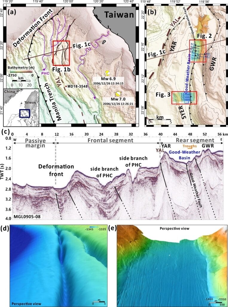
Figure 1. Study area in the Good-Weather Basin offshore southwestern Taiwan. High-resolution AUV bathymetry reveals numerous linear seafloor troughs that are difficult to resolve in conventional ship-based bathymetric data. These troughs are generally aligned parallel to the Good-Weather Fault, suggesting a possible structural control on their formation.